
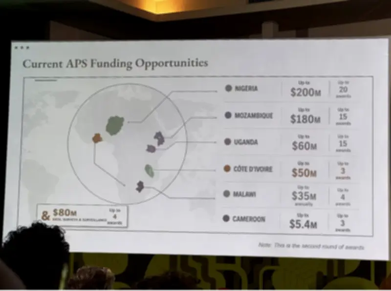
The United States State Department has formally acknowledged and apologized for displaying an artificial intelligence-generated map that incorrectly positioned several African countries during a presentation at the 26th International AIDS Conference (AIDS 2026) held in Brazil. The map, which was used in a session outlining new global health agreements, erroneously depicted Nigeria as a landlocked nation in the Sahara Desert instead of its actual location in West Africa. Mozambique was placed in the Horn of Africa rather than southeastern Africa, while Côte d'Ivoire appeared on the opposite side of the continent.
Errors Spotted by Attendees and Shared Online
Conference attendees photographed the erroneous slide and circulated it across social media platforms, drawing widespread attention. Reuters analyzed the presentation video and reported that the image bore a watermark indicating it was generated using OpenAI tools. OpenAI stated it was investigating the matter. The State Department attributed the mistake to a staff member who hastily modified the presentation shortly before the session. "We take full responsibility for the confusion and misrepresentation it caused for attendees, including our African partners," the department said in a statement.
Presentation by Senior PEPFAR Official
The slide was displayed during a presentation delivered by Jeff Graham, the senior US health official overseeing the President's Emergency Plan for AIDS Relief (PEPFAR), one of the world's largest HIV/AIDS programs. The incident drew sharp criticism from health and policy experts, who questioned how such geographical inaccuracies passed official quality checks. Matt Petit, an artificial intelligence and geopolitics specialist at the Atlantic Council, told Reuters the slide reflected a lack of basic geographical knowledge and inadequate quality control before it was presented.
Wider Impact and Ongoing Health Policy Context
The inaccurate map gained further attention after AIDS researcher Emily Bass shared screenshots in a Substack post, with images subsequently spreading across social media. The incident occurs amid a broader review of US overseas health assistance under President Donald Trump's administration. While PEPFAR has largely resumed supplying life-saving HIV medicines following last year's foreign aid review, US funding for disease prevention, surveillance, and other health programs has been reduced. The administration has also announced plans to phase out PEPFAR operations in South Africa as part of a shift in its global health strategy.
The State Department's acceptance of responsibility and the subsequent investigation by OpenAI underscore ongoing concerns about the use of AI tools in official capacities without rigorous verification. Critics argue that such errors could undermine trust in US health initiatives abroad. The mislabeling of African countries, in particular, highlighted challenges in maintaining accurate geographic and contextual knowledge when using AI-generated content. As the US continues to reshape its foreign aid priorities, this incident serves as a cautionary tale about the need for thorough oversight in the deployment of emerging technologies.